Quarterly Update December 2024
HEI Energy's December 2024 Quarterly Research Updates are now available. You will find the latest progress from each of our 8 exposure studies in communities affected by oil and gas development.
Project Updates
Water Quality Research
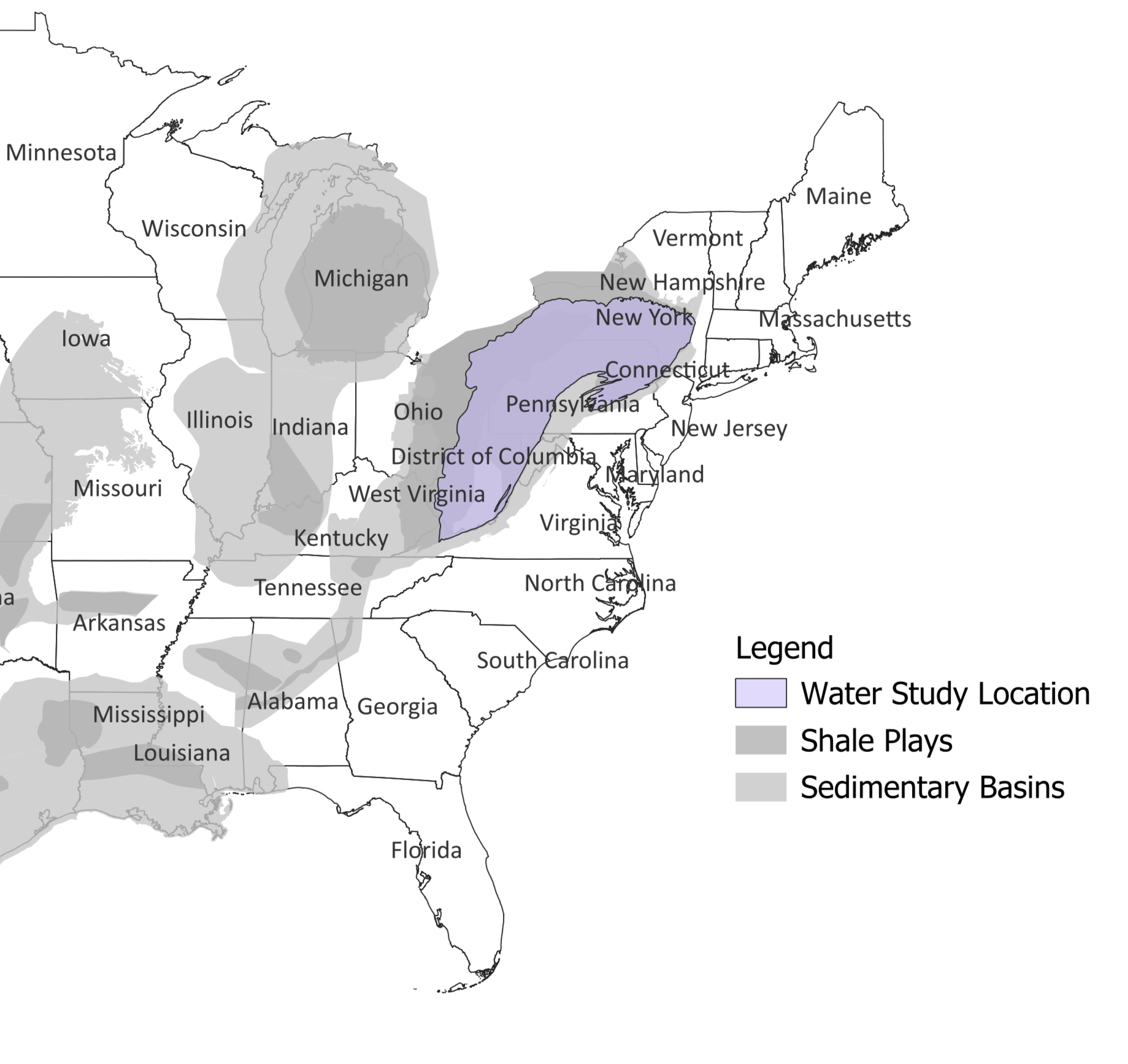
Using Geoscientific Analysis and Community Engagement to Analyze Exposures to Potential Groundwater Contamination
The overall goal of this study is to evaluate potential linkages between unconventional oil and gas development (UOGD) and groundwater contamination in a tri-county region of Pennsylvania with many overlapping potential sources of contamination. The analysis will be informed by focus groups in the region to help identify areas of community concern. The team plans to produce a broadly applicable framework to study the relationship between specific UOGD processes and potential groundwater contamination. The investigators will apply the following methods to achieve their goals:
- Combine an existing data set of chemical measurements in groundwater with machine learning to isolate the influences of natural and anthropogenic processes on groundwater chemistry and to identify chemical signatures of UOGD.
- Evaluate linkages between UOGD and potential water contamination.
- Develop an approach to map locations of potential contamination from UOGD activities for application to future investigations of potential human exposures and health effects associated with UOGD.

What's Happened
- Published the team’s first phase of research “Wastewaters Coproduced with Shale Gas Drive Slight Regional Salinization of Groundwater.”
- Completed water sampling program at 96 residences
What's New
- Continuing data analysis of water samples and residential survey data.
- Developing a literature review of the possible health effects of the analytes studied in water samples.
- Sharing water sampling results with study participants.
What's Next
- Complete field sampling and continue to finalize results.
- Continue returning results to participants.
- Prepare for community meetings to share results of the study.
A Groundwater Modeling Framework for Elucidating Community Exposures Across the Marcellus Region to Contamination Associated with Oil and Gas Development
The research team will build and test a model for understanding residential well water vulnerability to contamination from unconventional oil and gas development (UOGD) across the Marcellus region. This analysis will increase the understanding of risk to groundwater quality using publicly available data describing UOGD spills. The investigators will achieve their goal by:
- Modeling residential drinking water well vulnerability to contamination from UOGD sources over time across the Marcellus region. The model will describe how contaminants move in the subsurface.
- Using the model to understand the likelihood that specific UOGD spills will contaminate the water in residential wells.
- Refining the model and assessing its performance with statistical analyses using the characteristics of documented cases of UOGD spills and known contamination at well locations.
What's Happened
- Acquired data on spills associated with unconventional oil and gas development (UOGD) from state agencies.
- Cleaned the data, extracted essential information on spills, and integrated the geolocated observations into GIS.
- Analyzed published data on well water quality in Ohio, Pennsylvania, and West Virginia to identify potential chemical signatures of wastewater releases from UOGD.
- Acquired, processed, and combined hydrogeologic data to support calibration of a regional-scale groundwater flow model that will be used as a basis for well-water vulnerability estimates.
- Team member, Dr. Mario Soriano, presented “A groundwater modeling framework for elucidating drinking-water vulnerability to contamination by wastewater spills from oil and gas development” at GSA Connects Conference in Anaheim, CA.
- Team Principal Investigator, Dr. James Saiers, presented a Nelson Seminar at Syracuse University titled “Natural and anthropogenic processes affecting drinking-water quality within rural communities of the Appalachian Basin.”
What's New
- Running hydrologic models across the study region, accounting for possible factors that may influence model calibration and the flow and transport simulations.
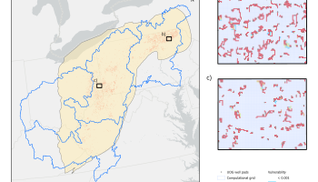
- Developing maps that show vulnerability to groundwater contamination using multiple particle tracking simulations with different set ups (see Figure ).
- Linking data on spill locations and timing with well impairments across the study area.
- Running preliminary logistic regression models to determine if the occurrence of a time-relevant spill within a close distance to a well affects the probability of its impairment.
Figure: Modeled estimates of hydrologic vulnerability to spills from unconventional oil and gas (UOG) development. Vulnerability quantifies the probability that any given location is along a groundwater transport pathway from a specified contaminant source, in this case a UOG well pad. We are evaluating vulnerability for aquifers overlying the Marcellus and Utica-Point Pleasant Shales at a grid scale of 250-meters through a large ensemble of hydrological models and particle tracking simulations. (Maps created by Mario Soriano, November 2024.)
What's Next
- Combine data on UOGD spills with modeled estimates of vulnerability to create spatially distributed estimates of UOGD-related risks in the Marcellus region.
- Complete statistical analyses of potential associations between spatially distributed risk estimates and observed incidences of well water contamination.
Upcoming Events
The research team will present “Towards a Risk-triage Platform for Assessing Groundwater Contamination from Fossil Fuel Extraction” at the American Geophysical Union Annual Meeting.
Air Quality and Noise Research
Measuring and Modeling Air Pollution and Noise Exposure Near Unconventional Oil and Gas Development in Colorado
The goal of this study is to develop community exposure profiles in the Colorado North Front Range for chemicals in the air as well as noise over the UOGD lifecycle, from site preparation through production of multi-well pads. This study will assess potential exposure pathways connecting UOGD chemical emissions to nearby communities and use the results to better understand the public health implications. The investigators will apply the following methods to achieve these goals:
- Use a combination of existing air quality data, innovative air quality measurements, and source apportionment models to quantify potential exposures.
- Collect noise measurements from UOGD operations to quantify potential exposures.
- In collaboration with the Hildebrandt Ruiz team, develop the "TRAcking Community Exposures and Releases" (TRACER) model for use in the Denver-Julesburg region to predict chemical emissions from specific UOGD processes. The teams will combine the predicted emissions with an air quality model to estimate concentrations of chemicals in the air.
- Evaluate model performance by comparing air quality monitoring data collected by this and the Franklin team with model predictions in the Denver-Julesburg region.

What's Happened
- Completed all air and noise monitoring for the study.
- Obtained final information regarding operational timelines from well pad operators.
- Dr. Collett presented an invited seminar on air quality impacts of oil and gas development to the Dept. of Civil and Environmental Engineering at Utah State University.
What's New
- Completing analyses of air and noise monitoring data and preparing the final study report.
- Finalizing the TRACER pre-production emissions model user interface and validating results against study observations.
What's Next
- Several presentations are scheduled for the December 2024 American Geophysical Union Annual Meeting and the January 2025 American Meteorological Society Annual Meeting.
- Da Pan, Weixin Zhang, Yong Zhou, I-Ting Ku, Seongjun Kim, Daniel Zimmerle, Jerry Duggan, Ethan Rimelman, Lisa M. McKenzie, Zachary Finewax, Pamela S Rickly, David Allen, Lea Hildebrandt Ruiz and Jeffrey Lee Collett Jr. An Emission Model for Volatile Organic Compounds from Unconventional Oil and Gas Development. To be presented at the American Geophysical Union Annual Meeting, December 10, 2024, Washington, DC.
- Weixin Zhang, Da Pan, I-Ting Ku and Jeffrey Lee Collett Jr. Using Ambient Concentration Measurements to Quantify Volatile Organic Compound Emissions from Unconventional Oil and Gas Operations. To be presented at the American Geophysical Union Annual Meeting, December 10, 2024, Washington, DC.
- Jeffrey Lee Collett Jr, Da Pan, Weixin Zhang, Yong Zhou, I-Ting Ku, Seongjun Kim, Zachary Finewax and Pamela S Rickly. Benzene and Other Air Toxics near Oil and Gas Well Pads During Well Drilling, Completions, and Early Production. To be presented at the American Geophysical Union Annual Meeting, December 12, 2024, Washington, DC.
- I-Ting Ku, Da Pan, Weixin Zhang, Yong Zhou, Emily Lachenmayer, Lena Low, Seongjun Kim and Jeffrey Lee Collett Jr. Characterizing Volatile Organic Compound Emissions from Synthetic Drilling Muds. To be presented at the American Geophysical Union Annual Meeting, December 12, 2024, Washington, DC.
- Jeffrey L. Collett Jr., D. Pan, W. Zhang, Y. Zhou, I. T. Ku, S. Kim, Z. Finewax, P. Rickly, J. Duggan, E. Rimelman, and D. Zimmerle. VOC Concentration Increases Near Oil and Gas Well Drilling, Completion, and Production Operations. To be presented at the American Meteorological Society Annual Meeting, January 15, 2025, New Orleans, LA.
- Da Pan, Weixin Zhang, Yong Zhou, I-Ting Ku, Seongjun Kim, Daniel Zimmerle, Jerry Duggan, Ethan Rimelman, Lisa M. McKenzie, Zachary Finewax, Pamela S Rickly, David Allen, Lea Hildebrandt Ruiz and Jeffrey Lee Collett Jr. An Emission Model for Volatile Organic Compounds from Unconventional Oil and Gas Development. To be presented at the American Geophysical Union Annual Meeting, December 10, 2024, Washington, DC.
- Participate in Energy & Health webinar series to describe findings from the TRACER collaboration research.
Assessing Source Contributions to Air Quality and Noise in Unconventional Oil Shale Plays
The goal of this study is to understand potential community exposure to UOGD-associated chemicals and radioactivity in air as well as noise. The investigators will apply the following methods to achieve their goals:
- Monitor air quality and noise in the Permian region of New Mexico and the Eagle Ford region of Texas to understand how potential exposures vary across the regions and over different time scales.
- Combine existing air monitoring data in the Denver-Julesburg region of Colorado and original data collected in the Permian and Eagle Ford regions with statistical models to distinguish UOGD from other sources of chemicals in the air and noise sources.
- Leverage satellite data to examine the association between natural gas flaring and air quality.
Collaborate with the Collett and Hildebrandt Ruiz teams to evaluate the "TRAcking Community Exposures and Releases" (TRACER) model performance in the Denver-Julesburg and Eagle Ford regions.
Online database with preliminary air concentration data collected by Dr. Franklin’s team. The data have not yet undergone HEI Energy’s rigorous peer review.

What's Happened
- Hosted Community Open House in Carlsbad, NM and presented results from local air monitoring.
- Presented an overview of results in a New Mexico state legislature hearing (Water and Natural Resources Committee).
What's New
- Completing analyses of air and noise monitoring and preparing the study final report.
- Ongoing passive samples of non-methane hydrocarbons being collected in the Eagle Ford Shale region, to wrap up at the end of December 2024
What's Next
- Host the next community outreach event in Spring 2025 (Date TBD). · Several presentations at the American Geophysical Union Fall Meeting December 9-13, 2024.
Predictive, Source-oriented Modeling and Measurements to Evaluate Community Exposures to Air Pollutants and Noise from Unconventional Oil and Gas Development
The goal of this study is to develop a broadly applicable model, the "TRAcking Community Exposures and Releases" (TRACER) model. The model will assess potential community exposures to chemicals in the air from UOGD and inform future health studies. The model will then be used to predict the magnitude and frequency of emissions from individual UOGD sources, and when coupled with dispersion modeling, will generate concentrations of chemicals in the air. The investigators will apply the following methods to achieve their goals:
- Collect stationary and mobile air quality and noise measurements in the Eagle Ford, Texas region.
- In collaboration with the Collett team, develop the TRACER model in the Eagle Ford region to generate chemical emissions data from specific UOGD processes. The teams will combine the predicted emissions with air quality models to estimate local and regional concentrations of chemicals in the air.
- Expansion of the TRACER model to the Marcellus region, leveraging data from the separately funded Appalachian Methane Initiative.
- Evaluate model performance by comparing air quality monitoring data with model predictions in the Eagle Ford region.
- Use TRACER model results to assess spatial and temporal variability of potential community exposures to UOGD-associated chemicals and evaluate the effects of different UOGD sources on potential community exposures.

What's Happened
- Submitted a paper titled “Fine Scale Spatial and Temporal Allocation of NOx Emissions from Unconventional Oil and Gas Development Results in Increased Predicted Regional Ozone Formation” and awaiting acceptance.
- Presented "Aerosol Formation from Oil and Gas Development in the Eagle Ford Shale" and "Volatile Organic Compound Emissions from Oil and Gas Development and Impacts on Aerosol Formation" at the AAAR Annual Conference (October 2024).
- Presented “Targeted Field Measurements of Methane and Co-Emitted Pollutants Inform Source Attribution” and posters at the annual Energy Emissions Modeling and Data Lab (EEMDL) Meeting at UT Austin.
What's New
- Completing analyses of air monitoring data and preparing the final study report.
What's Next
- Presenting several pieces at the American Geophysical Union Annual Meeting in Washington, DC (December 2024).
- Developing a web interface to access the TRACER model and underlying data.
- Participate in Energy & Health webinar series to describe findings from the TRACER collaboration research.
Air Quality Trends
Long-term criteria and toxic pollutants trends and community exposures over the Marcellus Shale in the U.S.
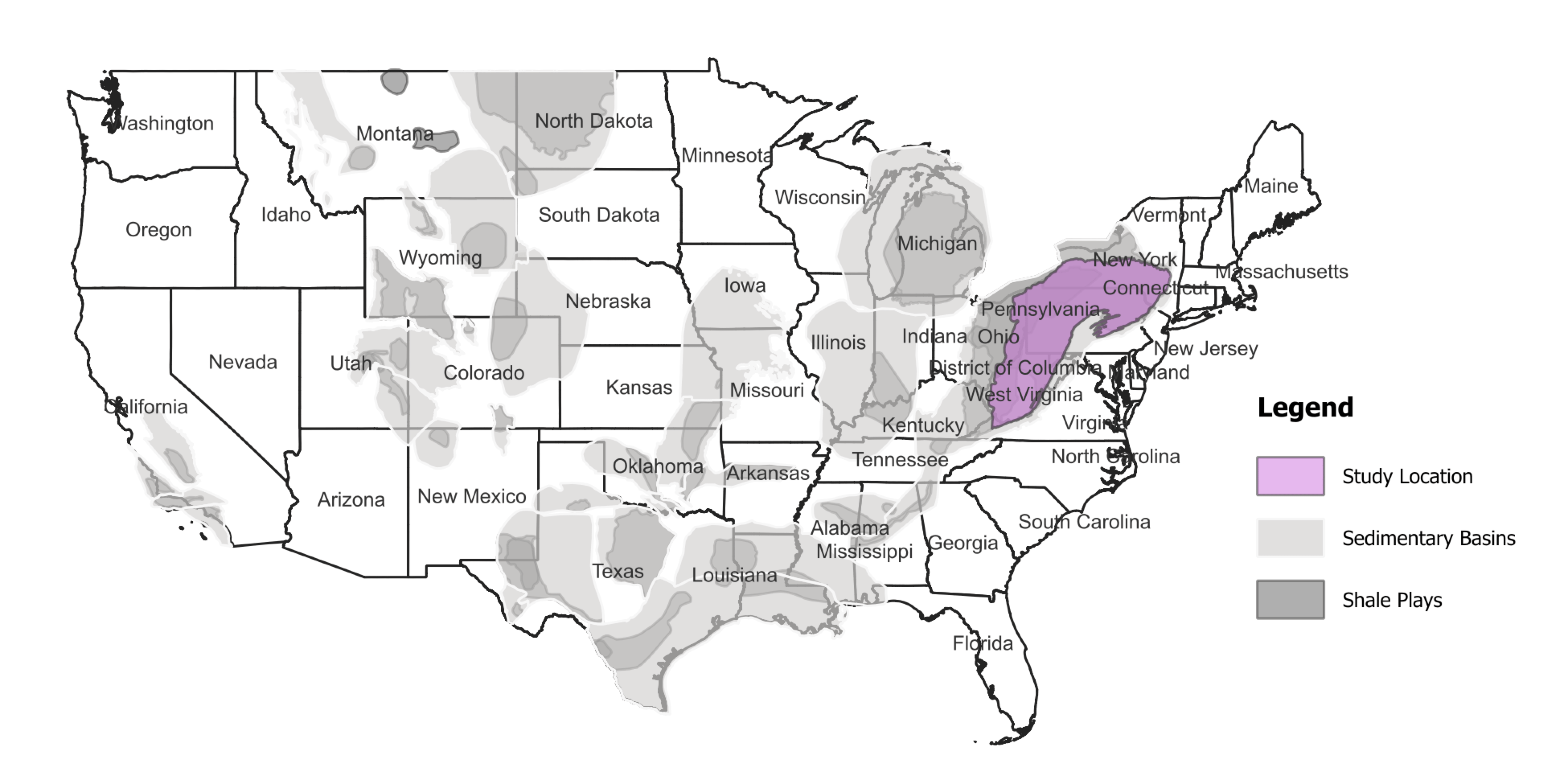
This study aims to assess trends in air quality and community exposures in the Marcellus Shale region and whether any might be explained by changes in oil and gas development-related operations or governance. The analysis will focus on local and regional exposures to criteria and hazardous air pollutants from 2002-2021, with special attention toward historically disadvantaged communities. The investigators are achieving their research aims with the following steps:
- Perform a long-term emissions trend analysis by integrating bottom-up oil and gas emissions and ambient measurements of criteria and select hazardous air pollutant concentrations.
- Conduct a long-term air quality trend analysis by applying a chemical transport model to simulate the criteria and select hazardous air pollutant concentrations over the region.
- Use a more advanced chemical transport model that employs machine-learning to investigate sources of and control strategies for oil and gas emissions.
- Apply a county-level community health vulnerability index approach to identify disproportionately exposed communities.
What's Happened
- Developed historical abandoned wells emissions inventory.
- Completed CAMx simulations for 2014 and 2019 years based on the latest U.S. EPA’s EQUATES criteria and hazardous air pollutant inventories.
- Started generating the rest of CAMx-ready meteorology and emissions inputs for additional study years.
- Trained the DeepCTM model (a machine-learning based chemical transport model) for four oil and gas-related air toxics (benzene, toluene, ethylbenzene, xylenes) based on CAMx inputs and outputs for 2008, 2014, and 2019.
- Processed abandoned well emissions through SMOKE and generated the 2008, 2014 and 2019 CAMx-ready gridded emissions inputs for CAMx simulations.
- Reviewed the CAMx outputs to estimate a county-level community health vulnerability index for PM2.5 and ozone, two key indicators of air quality.
- Presented “Long-term criteria and toxic pollutants trends in air quality and community exposures over the Marcellus Shale region in the U.S.” at the 2024 CMAS Conference in Chapel Hill, NC (October 2024).
Submitted the abstract titled “Spatial and Temporal Patterns in Air Quality and Community Exposure Disparities across the Marcellus Shale region in the U.S.” to the 2025 AAG conference in Detroit, MI (March 2025).
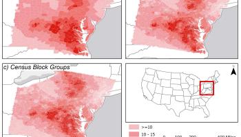
Figure 1. Average PM2.5 at the county, census tract, and census block groups level. Developed by UNT and HU teams.
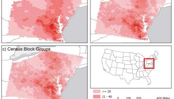
Figure 2. Total number of PM2.5 days above 35 µg/m3 (unhealthy for sensitive groups) at the county, census tract, and census block groups level. Developed by UNT and HU teams.
What's New
- Training the DeepCTM model for ozone based on the 2008, 2014, and 2019 CAMx inputs and outputs.
- Conducting additional CAMx simulations to improve the accuracy of ozone and air toxics concentrations with abandoned well emissions inventory data.
- Processing the CAMx outputs to estimate concentrations for PM2.5 and ozone at county, census tract, and census block group levels (See Figure 1 for an example for PM2.5).
- Associating the estimated PM2.5 and ozone levels with various socioeconomic and demographic variables.
- Estimating the number of people residing in areas with elevated PM2.5 and ozone over time (See Figure 2 for an example for PM2.5)
- Examining the relationship between community health vulnerability index and PM2.5 and ozone at the county level.
What's Next
- Analyze the long-term trends of emissions and measured concentrations over the Marcellus Shale region.
- Review oil and gas regulations over the years to assess how they may have affected emissions and air quality trends.
- Simulate two additional CAMx annual runs for 2008 and 2014 with the new additional abandoned well emissions inventory.
- Generate CAMx-ready gridded hourly data for abandoned well emissions over the remaining study period using the SMOKE emissions modeling system.
- Complete the DeepCTM training for air toxics and ozone.
- Simulate the long-term air quality concentrations using the DeepCTM based on the CAMx-ready emissions and meteorology inputs.
- Complete the community health vulnerability index analysis for PM2.5 and ozone over the counties within the Marcellus Shale region.
Trends in Marcellus-Utica Shale Regional Air Quality due to Unconventional Oil and Gas Development (TriMAQs)
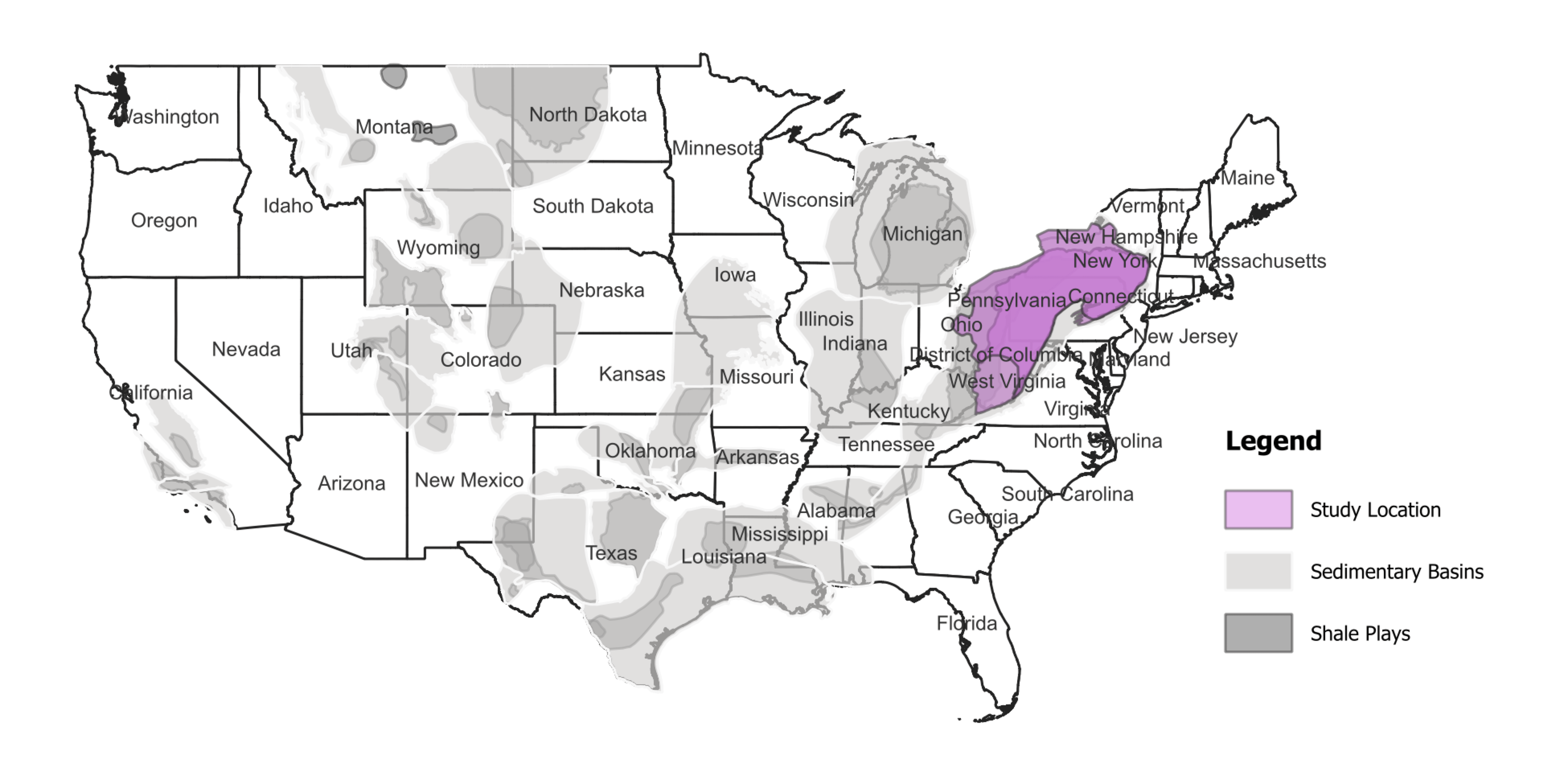
This study aims to understand how oil and gas development might contribute to any local or regional trends in air quality and associated population exposure across the Marcellus-Utica Shale region from 2004-2023. The team is assessing whether changes in operations or governance may have contributed to any observed trends. The investigators are achieving their research aims with the following steps:
- Organize daily air quality monitoring data for criteria air pollutants and volatile organic compounds into a single dataset for the study region from 2004-2023.
- Develop a dataset of daily oil and gas operational activity (including drilling, fracturing, transport, and gas compression) and an inventory of expected emissions across the study region for the same period as the air quality dataset (2004-2023).
- Estimate population exposure to the criteria air pollutants and volatile organic compounds, including exposures experienced by economically disadvantaged areas using the US Census American Community Survey data.
- Estimate the fraction of emissions in the region that come from oil and gas development and how changes in industry practice and governance might have led to changes in air quality.
What's Happened
- Completed the compilation of unconventional oil and gas well data, road traffic data, and power plant emissions data between 2004 and 2023 for the study region.
- Completed AERMOD dispersion modeling for 2018-2023, for SO2, NO2, and PM2.5.
- Team member Dr. Sourav Das presented “Integration of AERMOD and Machine Learning for Apportioning Air Pollutants to Unconventional Oil and Gas Activities in the Marcellus & Utica Shale Region” at the A&WMA Air Quality Models Conference in Raleigh, North Carolina (November 2024).
What's New
- Refining estimates of methane and other VOC emissions from well sites.
- Developing estimates of leakage from well sites and related fugitive emissions of natural gas and gas condensate.
- Calculating VOC emissions from power plants based on heat input and emission factors from the literature.
- Developing distribution of estimates for road traffic emissions using EPA MOVES and data on vehicle mix over the study period.
- Training and testing local scale dispersion models and satellite-based data models.
Comparing predicted and observed air quality data for the year 2023, which includes the significant Canadian wildfire event.
Figure 1: Predicted vs observed PM2.5 during the Canadian wildfire smoke event in 2023
What's Next
- Incorporate emissions wellsite trucks, compressors, fugitive emissions, condensate tanks, gas storage tanks, and venting/flaring to oil and gas operations to develop emissions estimates for all road traffic in the region.
- Complete survey of changes in industry practices and technology over the 2004-2023 time period.
- Complete dispersion modeling over the 2004-2023 time period.
- Apply machine learning to satellite observations of air pollutants and dispersion model output to obtain 1-km daily resolution air quality.
- Combine concentration maps with US census data to produce exposure estimates attributable to each source.
Upcoming Events
- Dr. Jeremy Gernand will present “Trends in exposure to air pollutants from Marcellus and Utica shale development” at the Society for Risk Analysis (SRA) Annual Meeting in Austin, TX (December 2024).
Air Quality Trends in Texas and Colorado Associated with Unconventional Oil and Gas Development
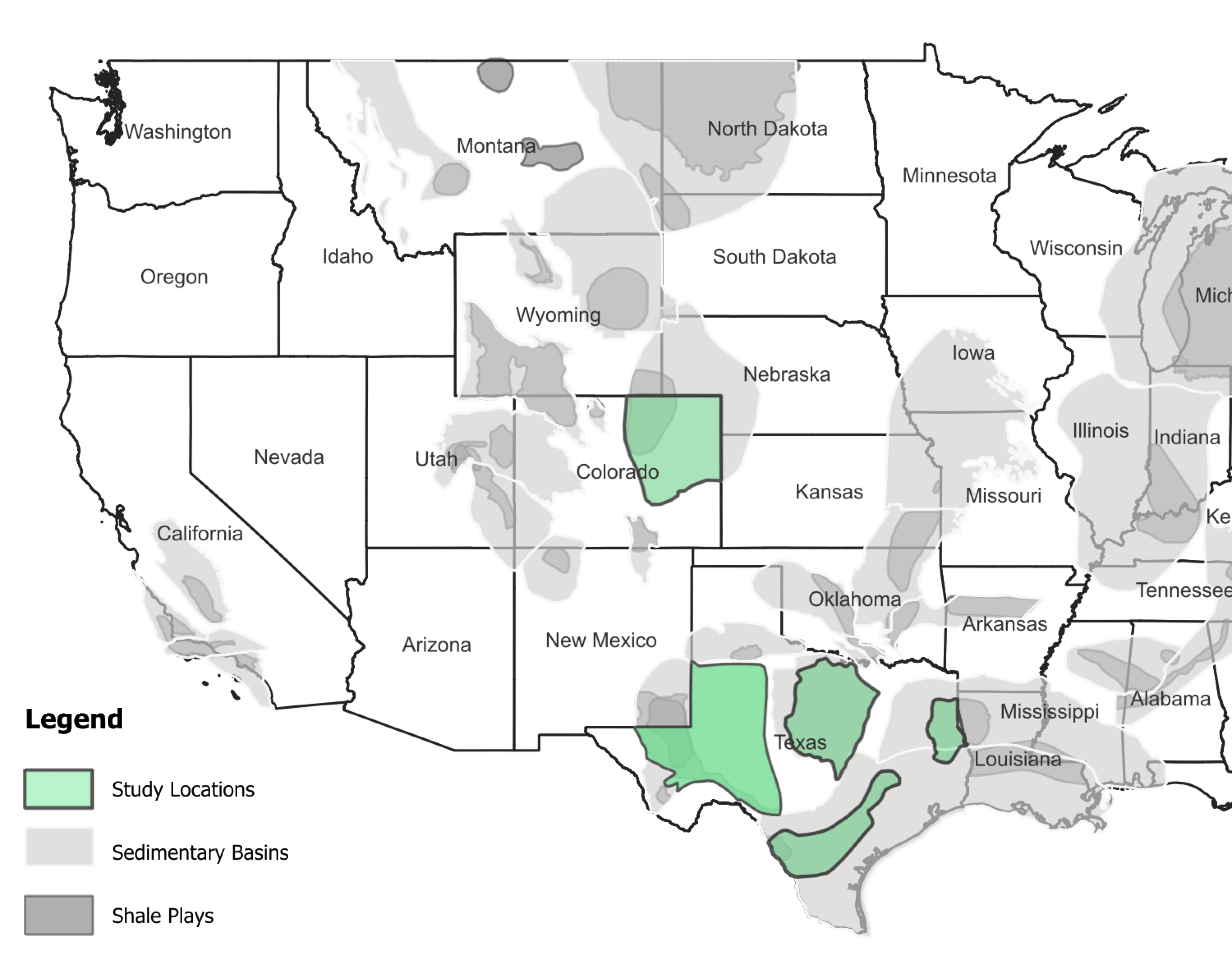
The overall goal of this study is to determine trends in the atmospheric concentrations of methane and non-methane hydrocarbons at eleven locations in the Haynesville, Eagle Ford, Barnett, and Permian regions of Texas and six locations in the Denver-Julesburg region of Colorado. The research team is using air quality monitoring data that date back as far as 1997 at one of the Texas locations, including:
- Texas Commission on Environmental Quality ambient air quality data collected in proximity and downwind of oil and gas production.
- Air quality data from the Colorado Department of Public Health & Environmental, the National Oceanic and Atmospheric
- Administration, and from a Northern Colorado Front Range Regional Government Coalition.
- Satellite-based measurements of formaldehyde above the Permian basin as a proxy for non-methane hydrocarbon emissions in the last 10 years.
The research team is separating long-term trends from seasonal and other short-term variations and is seeking to understand whether any observed trends are the result of changes in oil and gas operations or significant disruptions such as the COVID-19 pandemic shutdowns in 2020.
What's Happened
- Downloaded monitoring station data and completed quality assurance measures, such as considering the data quality flags provided by TCEQ, the correlations between compounds, and the consistency of time series.
- Began data analysis by analyzing meteorological data to evaluate year-over-year consistency of conditions at the monitoring sites.
- Plotted monthly chemical concentration statistics for individual sites, such as the mean and standard deviation, of NMHC time series data with focus on ethane, propane, and benzene (Figure 1a, site location: Boulder Reservoir [BRZ]).
- Created monthly plots illustrating chemical concentrations at individual sites (e.g., Figure 1b represents site “Longmont Union Reservoir [LUR]” in combination with “methane”)
- Completed de-seasoned trend modeling to understand changes in oil and gas production activity data.
What's New
- Using NOAA HYSPLIT trajectories to assess whether pollutants may be related to the oil and gas sector.
- Producing and evaluating finalized plots for sites and NMHC species.
- Comparing NOAA HYSPLIT trajectories for selected oil and gas regions and regions relatively unaffected by oil and gas development.
- Conducting exploratory data analysis at selected sites to determine the best approach to identify factors of oil and gas operations in air quality trend analysis.
What's Next
- Finalize explorational plotting and provide overviews of the data at each site
- Conduct a comparison of pollutant levels during COVID-19 shutdown periods versus non-shutdown years to assess the impact of reduced human-based activities.
- Acquire the necessary satellite data to begin exploring Permian Basin NMHC trends.
Figure 1


