
Quarterly Update September 2024
HEI Energy's September 2024 Quarterly Research Updates are now available. You will find the latest progress from each of our 8 exposure studies in communities affected by oil and gas development.
Project Updates
Water Quality Research
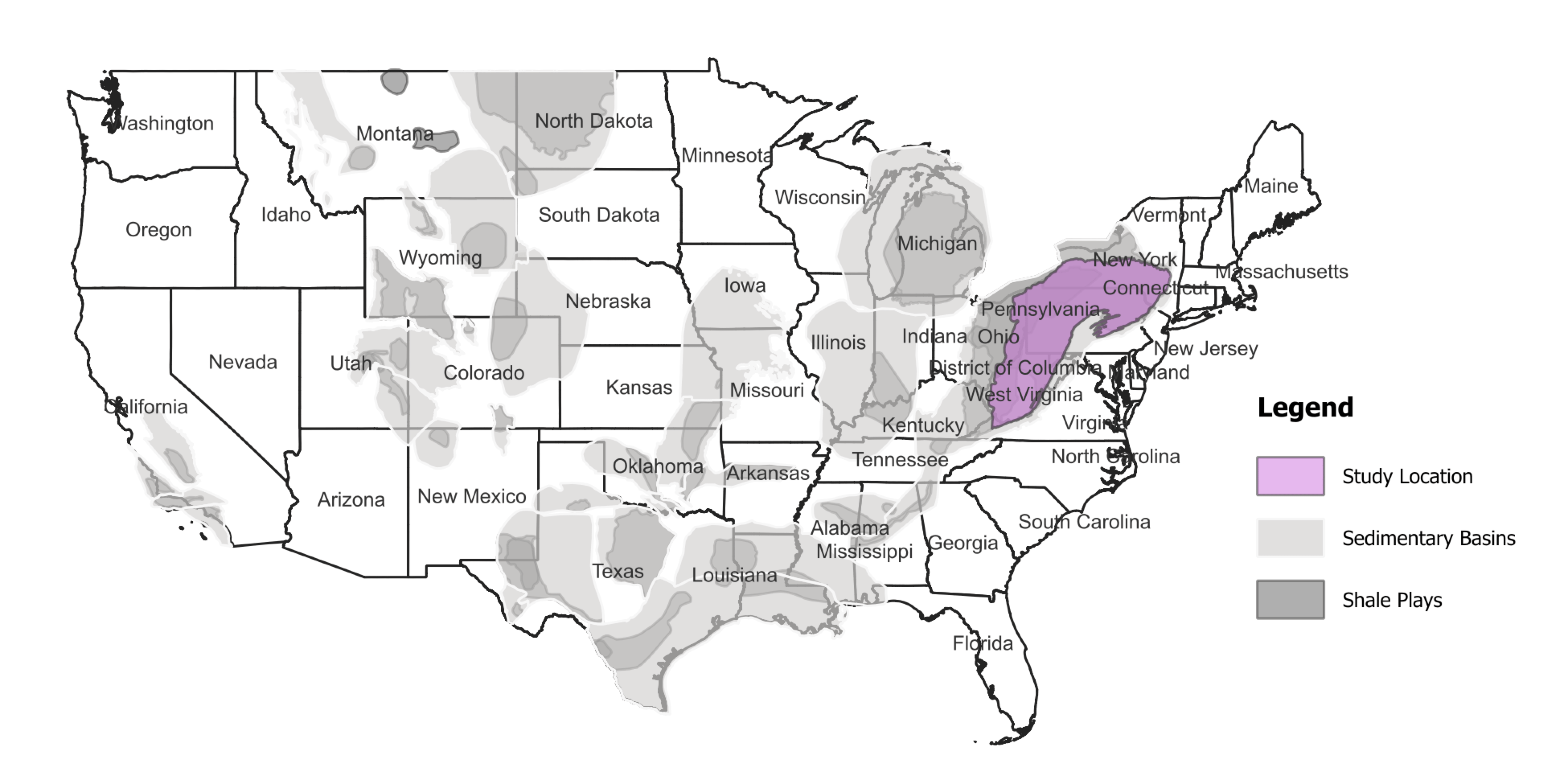
Using Geoscientific Analysis and Community Engagement to Analyze Exposures to Potential Groundwater Contamination
The overall goal of this study is to evaluate potential linkages between unconventional oil and gas development (UOGD) and groundwater contamination in a tri-county region of Pennsylvania with many overlapping potential sources of contamination. The analysis will be informed by focus groups in the region to help identify areas of community concern. The team plans to produce a broadly applicable framework to study the relationship between specific UOGD processes and potential groundwater contamination. The investigators will apply the following methods to achieve their goals:
- Combine an existing data set of chemical measurements in groundwater with machine learning to isolate the influences of natural and anthropogenic processes on groundwater chemistry and to identify chemical signatures of UOGD.
- Evaluate linkages between UOGD and potential water contamination.
- Develop an approach to map locations of potential contamination from UOGD activities for application to future investigations of potential human exposures and health effects associated with UOGD.

What's Happened
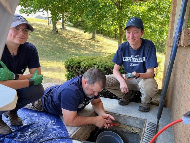
- Collected water samples from wells from 82 residences in southwestern Pennsylvania.
- Participated in a National Academies of Sciences workshop on July 18-19, 2014, titled “Practices and Standards for Plugging Orphaned and Abandoned Hydrocarbon Wells,” which was informed by this HEI Energy-funded research.
- Presented the rationale for the study and research plan in a poster session at HEI's 2024 Annual Conference.
What's New
- Conducting one more field trip to finalize residential water sample collection.
- Beginning data analysis of the residential water samples and survey data.
What's Next
- Share water sampling results with study participants.
- Prepare for community meetings where study results will be presented more broadly.
- Communicate all study findings in accordance with the Community Engagement Plan for this study.
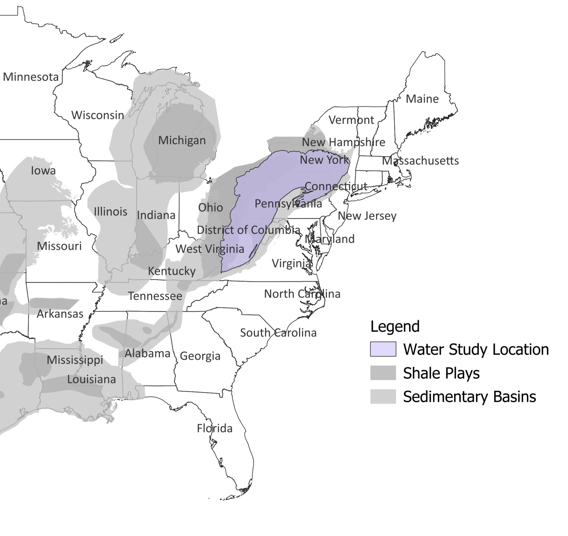
A Groundwater Modeling Framework for Elucidating Community Exposures Across the Marcellus Region to Contamination Associated with Oil and Gas Development
The research team will build and test a model for understanding residential well water vulnerability to contamination from unconventional oil and gas development (UOGD) across the Marcellus region. This analysis will increase the understanding of risk to groundwater quality using publicly available data describing UOGD spills. The investigators will achieve their goal by:
- Modeling residential drinking water well vulnerability to contamination from UOGD sources over time across the Marcellus region. The model will describe how contaminants move in the subsurface.
- Using the model to understand the likelihood that specific UOGD spills will contaminate the water in residential wells.
- Refining the model and assessing its performance with statistical analyses using the characteristics of documented cases of UOGD spills and known contamination at well locations.
What's Happened
- Acquired data from Ohio Department of Natural Resources about spills from oil and gas wells.
- Filed a Freedom of Information Act (FOIA) request with West Virginia to obtain data about spills from oil and gas wells.
- Requested and received information from the Pennsylvania Department of Environmental Protection for accessing data about spills from oil and gas wells. •Collected water quality data from Yale WATER Study.
- Presented the rationale for the study and research plan in a poster session at HEI's 2024 Annual Conference.
What's New
- Processing data received from state agencies on spill locations and characteristics.
- Commencing development of a regional-scale groundwater flow model to support estimates of drinking water vulnerability to unconventional oil and gas (UOG) contamination.
- Acquiring additional sources of data on well water quality for Pennsylvania.
What's Next
- Continue expansion of geographic coverage of groundwater flow and particle-tracking model, collect and harmonize data on groundwater levels and discharge, and calibrate the expanded model against these hydrologic observations to enable predictions of drinking water vulnerability across the 220,000 km2 area covering the Marcellus Shale region.
- Complete acquisition and database development for UOG spills.
- Complete acquisition and quality-control checks on groundwater impairment data.
Upcoming Events
- The research team will present a poster titled “A groundwater modeling framework for elucidating drinking-water vulnerability to contamination by wastewater spills from oil and gas development” at the Geological Society of America Connects 2024 Meeting in Anaheim, CA on September 22-27, 2024.
- The research team will present another poster titled “Towards a risk-triage platform for assessing potential groundwater contamination from fossil fuel extraction” at the American Geophysical Union Conference in Washington, DC on December 9-13, 2024.
Air Quality and Noise Research
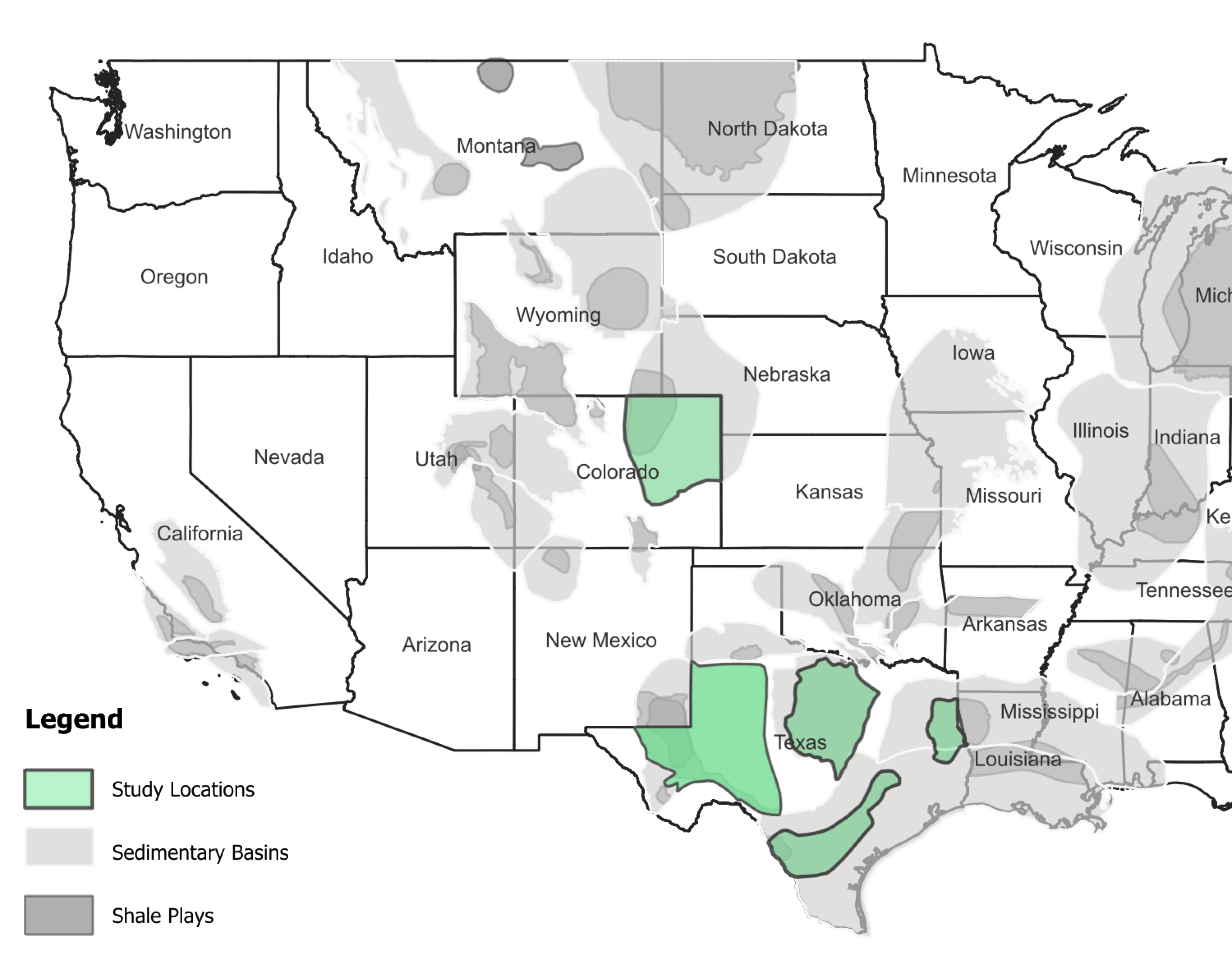
Measuring and Modeling Air Pollution and Noise Exposure Near Unconventional Oil and Gas Development in Colorado
The goal of this study is to develop community exposure profiles in the Colorado North Front Range for chemicals in the air as well as noise over the UOGD lifecycle, from site preparation through production of multi-well pads. This study will assess potential exposure pathways connecting UOGD chemical emissions to nearby communities and use the results to better understand the public health implications. The investigators will apply the following methods to achieve these goals:
- Use a combination of existing air quality data, innovative air quality measurements, and source apportionment models to quantify potential exposures.
- Collect noise measurements from UOGD operations to quantify potential exposures.
- In collaboration with the Hildebrandt Ruiz team, develop the "TRAcking Community Exposures and Releases" (TRACER) model for use in the Denver-Julesburg region to predict chemical emissions from specific UOGD processes. The teams will combine the predicted emissions with an air quality model to estimate concentrations of chemicals in the air.
- Evaluate model performance by comparing air quality monitoring data collected by this and the Franklin team with model predictions in the Denver-Julesburg region.

What's Happened
- Concluded air monitoring at the initial study well-pad near Aurora, Colorado. Monitoring began before drilling and continued through well completions and several months of production.
- Simulated emissions and air dispersion around the initial study well pad near Aurora and completed an initial comparison between predicted and observed concentration distributions during specific UOGD operations. Observed the largest disagreement during production operations, where concentrations of key volatile organic compounds, such as ethane and benzene , were several times higher than predicted.
- Completed noise monitoring for the study, which included monitoring around hydraulic fracturing operations in Windsor, Colorado.
- Presented noise measurements collected during drilling at a study pad near Brighton. Graduate student Phillip Stepherson presented the measurements in a poster session at the Environmental and Occupational Health Research Exchange Day at Colorado State University.
- Presented the rationale for the study and research plan in a poster session at HEI's 2024 Annual Conference.
What's New
- Continuing air monitoring around production operations at two UOGD pads near Windsor, Colorado.
- Engaging with the operator in Windsor, Colorado to better understand and address sources of elevated emissions, as unanticipated rates of benzene emissions measured around the facilities have delayed plans to conclude air monitoring at this location.
- Refining the TRACER pre-production emissions model and finalizing model-observation comparisons.
- Examining noise observations during drilling operations at the second study pad near Brighton, Colorado, and during hydraulic fracturing operations at the final study pads near Windsor. This includes reducing and cleaning the remaining noise data collected at the Brighton pad and all noise data collected at the Windsor pads as well as analyzing the final data in the context of wind observations and operator activities.
- Collaborating with Larimer County to prepare input for upcoming Colorado ECMC hearings on cumulative impacts of UOGD.
What's Next
- Finish air monitoring operations around production operations at the Windsor, Colorado, study well pads and finalize analysis of air toxics, other VOCs, and NOx observations from that location.
- Expand emission model user choices for operational practices and associated emission rates to provide greater utility for application to UOGD operations with practices that differ from those in our study location within the Denver-Julesburg Basin.
- Prepare summaries and interpretations of noise results.
- Prepare the project final report for HEI Energy.
- Collaborate with HEI Energy to plan and conduct a final outreach event(s) for the project.
Upcoming Events
- Submitted four abstracts for review for presentation at the December 9-13, 2024 Annual Meeting of the American Geophysical Union. Details of accepted abstracts and presentation schedules will be provided in the next update.
- Dr. Collett will deliver a seminar on air quality impacts of oil and gas development at Utah State University in October 2024.
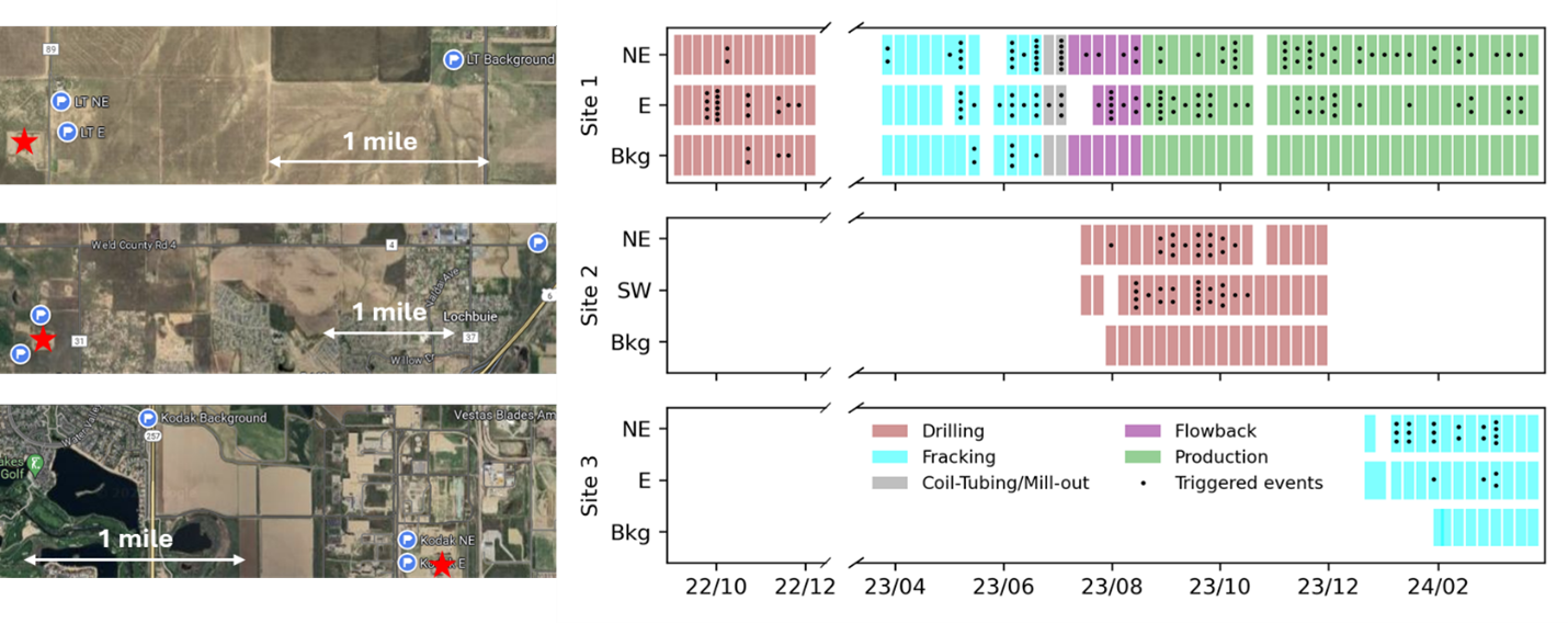
Figure 1. Well pad (red stars) and air monitoring (white flags on blue circles) site locations at 4 well pads near Aurora (Site 1), Brighton (Site 2), and Windsor (Site 3, two well pads studied at this location), Colorado. Each study site includes two near-pad and one more distant background monitoring location. UOGD operations timelines and air monitoring timelines are shown in the right panels. Filled bars indicate sampling periods of integrated weekly canisters. Dots indicate collection times of plume-triggered canisters. CDPHE CAMML, CSU mobile, and CU Denver noise monitoring operations are not shown in these summary timelines.
Prepared by Da Pan
Assessing Source Contributions to Air Quality and Noise in Unconventional Oil Shale Plays
The goal of this study is to understand potential community exposure to UOGD-associated chemicals and radioactivity in air as well as noise. The investigators will apply the following methods to achieve their goals:
- Monitor air quality and noise in the Permian region of New Mexico and the Eagle Ford region of Texas to understand how potential exposures vary across the regions and over different time scales.
- Combine existing air monitoring data in the Denver-Julesburg region of Colorado and original data collected in the Permian and Eagle Ford regions with statistical models to distinguish UOGD from other sources of chemicals in the air and noise sources.
- Leverage satellite data to examine the association between natural gas flaring and air quality.
Collaborate with the Collett and Hildebrandt Ruiz teams to evaluate the "TRAcking Community Exposures and Releases" (TRACER) model performance in the Denver-Julesburg and Eagle Ford regions.
Online database with preliminary air concentration data collected by Dr. Franklin’s team. The data have not yet undergone HEI Energy’s rigorous peer review.

What's Happened
- Completed stationary air quality monitoring in Loving, NM.
- Finalized passive sampling data collection in the Carlsbad/Loving, NM region.
- Represented by Dr. Schade, the team presented an overview of results in a New Mexico state legislature hearing (Legislative Finance Committee) in Carlsbad, NM
- Presented “Seasonal Methane Measurements in the Western Permian Basin, Loving, NM” at the American Chemical Society Fall Symposium.
Presented the rationale for the study and research plan in a poster session at HEI's 2024 Annual Conference.
Image
What's New
- Completing extensive QA/QC on all data collected at the stationary site from April 2023 through May 2024
- Finalizing QA/QC on all passive sample data collected in the Permian Basin.
- Starting passive sampling in the Eagle Ford Shale, with 5 sites located in the Karnes City, TX area.
What's Next
- Focus on data analyses, modeling, and writing. The team has 7 papers planned and has submitted 5 abstracts to the American Geophysical Union Fall Meeting.
Upcoming Events
- The team will be hosting a Community Webinar in early October 2024.
- The team will be participating in the American Geophysical Union Fall Meeting. in December 2024.
Photo caption: Passive sampler setup in Karnes, TX (Photo Credit: Co-I Gunnar Schade)
Predictive, Source-oriented Modeling and Measurements to Evaluate Community Exposures to Air Pollutants and Noise from Unconventional Oil and Gas Development
The goal of this study is to develop a broadly applicable model, the "TRAcking Community Exposures and Releases" (TRACER) model. The model will assess potential community exposures to chemicals in the air from UOGD and inform future health studies. The model will then be used to predict the magnitude and frequency of emissions from individual UOGD sources, and when coupled with dispersion modeling, will generate concentrations of chemicals in the air. The investigators will apply the following methods to achieve their goals:
- Collect stationary and mobile air quality and noise measurements in the Eagle Ford, Texas region.
- In collaboration with the Collett team, develop the TRACER model in the Eagle Ford region to generate chemical emissions data from specific UOGD processes. The teams will combine the predicted emissions with air quality models to estimate local and regional concentrations of chemicals in the air.
- Expansion of the TRACER model to the Marcellus region, leveraging data from the separately funded Appalachian Methane Initiative.
- Evaluate model performance by comparing air quality monitoring data with model predictions in the Eagle Ford region.
- Use TRACER model results to assess spatial and temporal variability of potential community exposures to UOGD-associated chemicals and evaluate the effects of different UOGD sources on potential community exposures.

What's Happened
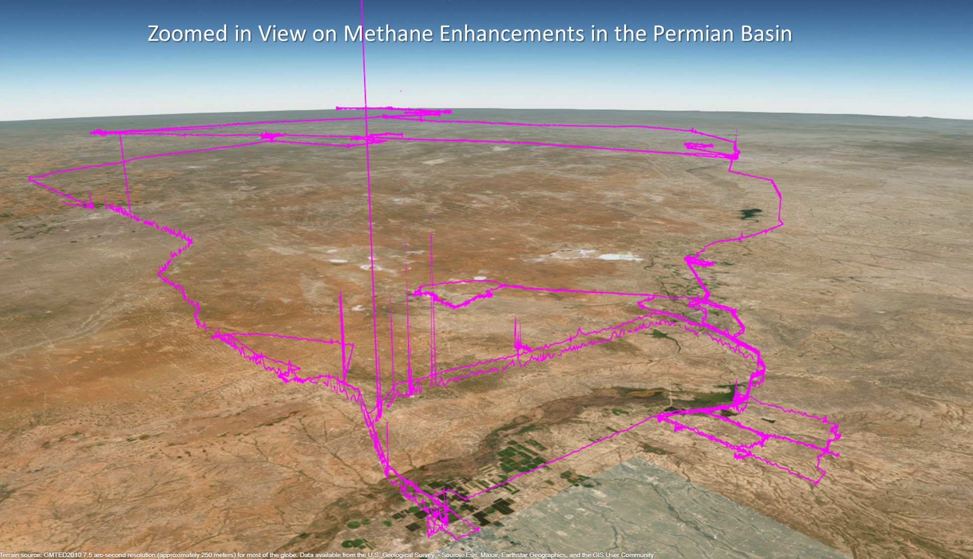
- Analyzed the data collected during mobile measurements in the Permian Basin. Figure 1 illustrates methane measurements collected from the team’s mobile measurement platform during that campaign.
- Finalized the analysis of data from flaring emissions in the Eagle Ford Shale and discovered that emission factors vary by two orders of magnitude.
- Modeled concentrations at the receptor site in Karnes City, Texas, and determined that assumptions about the effectiveness of tank control significantly impact the agreement between modeled and measured VOC concentrations.
- Presented the rationale for the study and research plan in a poster session at HEI's 2024 Annual Conference.
What's New
- Collaborating between the measurements and modeling teams to implement flaring emissions in the TRACER model.
- Continuing work on including air toxic emissions from tank flashes in the TRACER
What's Next
- Run the TRACER model with flaring emissions included to provide updated estimates of human exposures to pollutants from UOGD.
- Continue analysis of data collected in the Permian Basin.
Upcoming Events
- The research team will present two papers titled Aerosol Formation from Oil and Gas Development in the Eagle Ford Shale and Volatile Organic Compound Emissions from Oil and Gas Development and Impacts on Aerosol Formation at the Annual Meeting of the American Association for Aerosol Research (AAAR) on Tuesday, October 22, 2024 during Session 2.
- The research team will submit several abstracts to the Fall Meeting of the American Geophysical Union, titled Temporal Allocation of Methane and Criteria Air Pollutant Emissions from Oil and Gas Operations and Using Hydrocarbon Concentrations at Regional Monitors in Oil and Gas Regions to Detect and Assess the Durations of Large Emission Events.
Air Quality Trends
Long-term criteria and toxic pollutants trends and community exposures over the Marcellus Shale in the U.S.
This study aims to assess trends in air quality and community exposures in the Marcellus Shale region and whether any might be explained by changes in oil and gas development-related operations or governance. The analysis will focus on local and regional exposures to criteria and hazardous air pollutants from 2002-2021, with special attention toward historically disadvantaged communities. The investigators are achieving their research aims with the following steps:
- Perform a long-term emissions trend analysis by integrating bottom-up oil and gas emissions and ambient measurements of criteria and select hazardous air pollutant concentrations.
- Conduct a long-term air quality trend analysis by applying a chemical transport model to simulate the criteria and select hazardous air pollutant concentrations over the region.
- Use a more advanced chemical transport model that employs machine-learning to investigate sources of and control strategies for oil and gas emissions.
- Apply a county-level community health vulnerability index approach to identify disproportionately exposed communities.
What's Happened
- Initiated the study in collaboration with researchers at George Mason University, Howard University, and Eastern Research Group.
- Gathered unconventional oil and gas development (UOGD)-related emissions inventory and air quality monitoring datasets to assess air quality trends over the Marcellus Shale region.
- Started simulating concentrations of nitrogen dioxide, ozone, particulate matter (PM2.5), and selected air toxics including benzene, toluene, ethylbenzene, and xylene (BTEX) compounds, naphthalene, styrene, acrolein, and formaldehyde) for the period of 2002-2021. To start, they have completed simulations of hazardous air pollutants (HAPs) in the Marcellus Shale region for 2004, 2018, and 2019, which represent significant years in regulatory policy over UOGD sources.
- Completed modeling the 2008 annual CAMx simulations for targeted air pollutants.
- Presented the rationale for the study and research plan in a poster session at HEI's 2024 Annual Conference.
What's New
- Reviewing and analyzing the 20-year UOGD-related emissions inventory and air quality monitoring datasets to understand long-term trends in air quality and possible associations with UOGD regulatory policy implementations.
- Evaluating the performance of the 2008 CAMx air quality modeling simulations for ozone, PM2.5, and HAPs by comparing them with air quality monitoring datasets gathered by the ERG team.
- Based on preliminary outputs from the CAMx model, train an artificial intelligence modeling system to mimic the CAMx modeling performance and generate spatiotemporal air quality datasets over the Marcellus Shale region.
What's Next
- Continue review of UOGD-related emissions inventory and monitoring datasets.
- Conduct modeling simulations of air quality using CAMx for 2014 and 2019.
- Using the CAMx model, analyze ozone and PM2.5 concentrations to understand potential UOGD-related sources and how they may have impacted local and regional air quality over the study period.
Air Quality Trends in Texas and Colorado Associated with Unconventional Oil and Gas Development
The overall goal of this study is to determine trends in the atmospheric concentrations of methane and non-methane hydrocarbons at eleven locations in the Haynesville, Eagle Ford, Barnett, and Permian regions of Texas and six locations in the Denver-Julesburg region of Colorado. The research team is using air quality monitoring data that date back as far as 1997 at one of the Texas locations, including:
- Texas Commission on Environmental Quality ambient air quality data collected in proximity and downwind of oil and gas production.
- Air quality data from the Colorado Department of Public Health & Environmental, the National Oceanic and Atmospheric
- Administration, and from a Northern Colorado Front Range Regional Government Coalition.
- Satellite-based measurements of formaldehyde above the Permian basin as a proxy for non-methane hydrocarbon emissions in the last 10 years.
The research team is separating long-term trends from seasonal and other short-term variations and is seeking to understand whether any observed trends are the result of changes in oil and gas operations or significant disruptions such as the COVID-19 pandemic shutdowns in 2020.
What's Happened
- Completed the Quality Assurance/Quality Control plan for the study, which has been approved by the HEI Energy Research Committee.
- Presented the rationale for the study and research plan in a poster session at HEI's 2024 Annual Conference.
What's New
- Coordinating research activities with Boulder Air.
What's Next
- Download data from monitoring stations.
- Acquire satellite data.
What's Happened
- Collected well activity data from state-level databases and Drillinginfo.com, including details on location, start date, production, drilling duration, depth, and later length.
- Collected ground-level chemical concentration data from the EPA. Conducted data validation and preparation land cover and building footprint data from the National Land Cover Database by the USGS and FEMA.
- Collected remote sensing data on pollutant concentrations for the study region.
- Defined the grid map for the study region at 1km resolution.
- Collected and mapped daily traffic volumes for the study region.
- Presented the rationale for the study and research plan in a poster session at HEI's 2024 Annual Conference.
What's New
- Completing a search for public sources of ground-level ambient concentrations of chemicals.
- Preparing data required to test the well site local dispersion model.
- Performing preliminary modeling runs of the chosen 1km resolution grid map.
- Collecting waste disposal data from state-level databases on unconventional wells in the study region.
What's Next
- Model UOGD emissions and predict chemical concentrations in air and assess the degree to which UOGD activity is correlated with and predictive of observed ambient chemical concentrations as compared to other sources.
- Generate estimates of population exposure to UOGD emissions and estimate exposure for people living in economically disadvantaged areas.
